Physical Geography

Title: Physical Geographical Features of Western Europe
Orientation: North, East, South, and West
Date: 11/11/16
Author: Freeworldmaps.net
Legend: Blue=water; brown= mountain range; green=land
Scale: 1 inch=125 miles
Index: N/A
Grid: Given
Surrounding areas: North, East, South Europe
Orientation: North, East, South, and West
Date: 11/11/16
Author: Freeworldmaps.net
Legend: Blue=water; brown= mountain range; green=land
Scale: 1 inch=125 miles
Index: N/A
Grid: Given
Surrounding areas: North, East, South Europe
Austria - Alps Mountains Danube River, Lake Constance, Semmering Pass, River Drau
Belgium - Meuse River, Ardennes uplands, Botrange peak, Schelde River
France - Alps Mountains, Pyrenees Mountains, Rhine River, English Channel
Germany - North European Plain, Harz Mountains, Bohemian Forest, Rhine RIver Valley
Liechtenstein - Rhine RIver Valley, Alps Mountains, Rhätikon Mountains, Grauspitz Peak
Luxembourg - Alzette, Eisch, Moselle, Our and Sure Rivers; Andrennes Mountains
Monaco - Alpes-Maritimes foothills, Mediterranean Sea, Mont Agel
Netherlands - Ardennes Mountains, North Sea Canal; Rijn, Mass, Scheldt and Waal Rivers
Switzerland - Alps Mountains, Pennine Alps, Jura Mountains, Rhine River
Significance of Physical Features
Many of the natural surface features form borders between countries and regions. The Pyrenees Mountains, Bay of Biscay, and Ligurian Sea form the western border of the region while Oder River forms the eastern boundary. Between the Pyrenees and Ural Mountains is the Great European Plain, an area with rich soil and an abundance of agriculture. Another major agricultural area are the surrounding places adjacent to the Rhine River, another natural border between France and Germany. Major mountains include the Pyrenees and Alps that act as an obstruction to migration, transportation, and settlement.
Political Geography
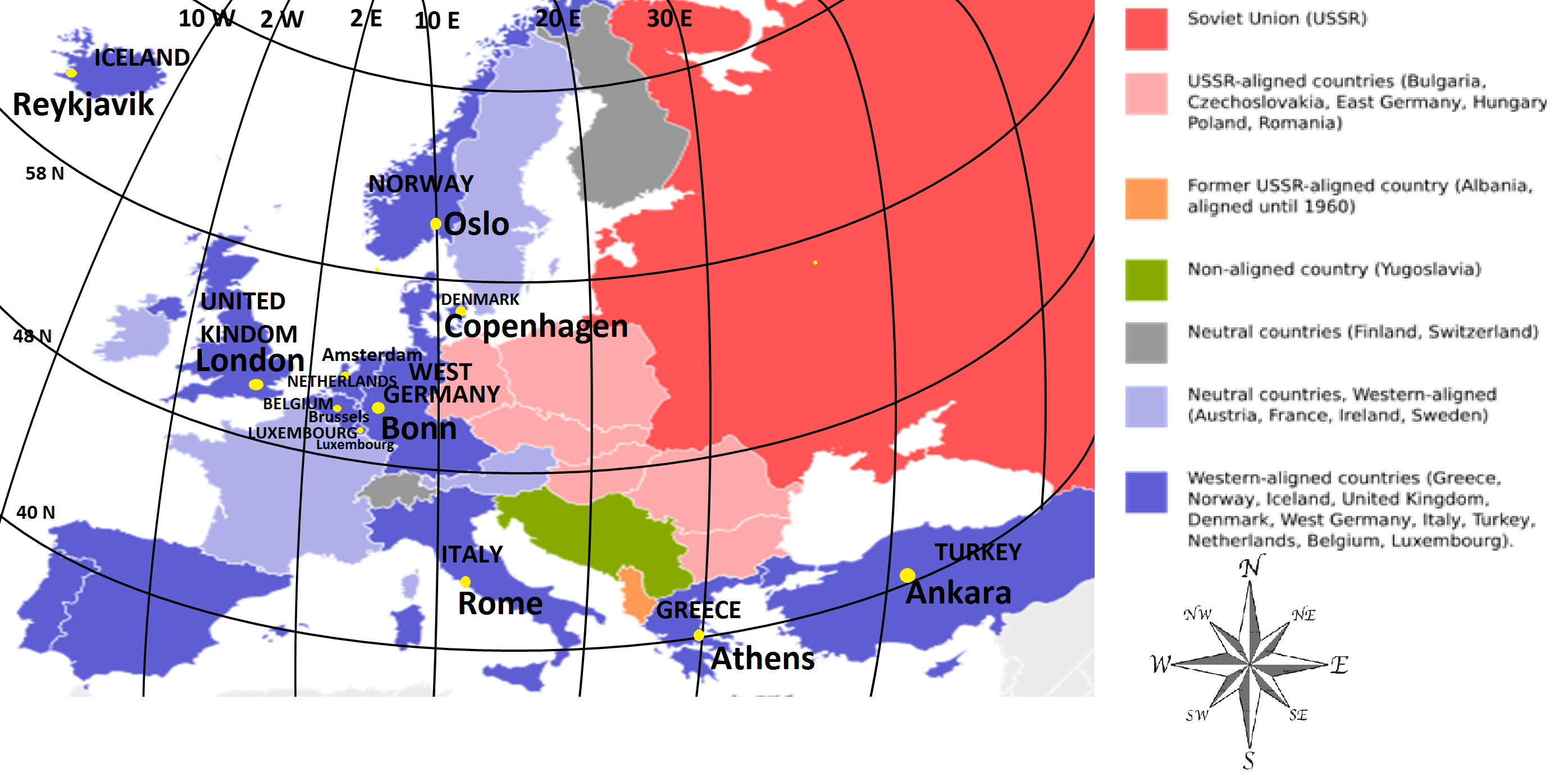
Title: Political Geography of Western Europe Cold War Era
Orientation: North, East, South, West
Date: 11/11/16
Author: Wikimedia
Legend: Given
Black=Country
Yellow=Capital
Scale: 1 inch=125 miles
Index: N/A
Grid:Shown above
Surrounding areas: USSR, neutral countries
Orientation: North, East, South, West
Date: 11/11/16
Author: Wikimedia
Legend: Given
Black=Country
Yellow=Capital
Scale: 1 inch=125 miles
Index: N/A
Grid:Shown above
Surrounding areas: USSR, neutral countries

Title: Political Geography of Western Europe Modern Era
Orientation: North, East, South, West
Date: 11/11/16
Author: Freeworldmaps.net
Legend: Blue=water, color=Western Europe, Grey=other countries
Scale: 1 inch=70 miles
Index: Lie-Liechtenstein
Grid: Given
Surrounding areas: North, East, South Europe
Orientation: North, East, South, West
Date: 11/11/16
Author: Freeworldmaps.net
Legend: Blue=water, color=Western Europe, Grey=other countries
Scale: 1 inch=70 miles
Index: Lie-Liechtenstein
Grid: Given
Surrounding areas: North, East, South Europe
Change in Borders Over Time
The borders of Western Europe have significantly changed since 1939, mainly because of the shift from World War II alliances to a geographical based categorization system. The term "Western Europe" in 1939 defined the the western aligned countries that fought against the USSR. These countries included Greece, Norway, Iceland, the United Kingdom, Denmark, West Germany, Italy, Turkey, Netherlands, Belgium, and Luxembourg. After World War II, this categorization was no longer necessary. Austria, Belgium, France, Germany, Liechtenstein, Luxembourg, Monaco, Netherlands, and Switzerland were then grouped by the UN as a region based on similar cultures, climates, and a shared border made of natural land features.
